http://www.sanparks.org/assets/docs/con ... nation.pdf
REVISED ZONING SYSTEM
Kruger National Park
EXECUTIVE SUMMARY
In the last approved management plan South African National Parks reflected on the need to re-think the zonation system for the Kruger National Park (Kruger NP) to reflect the complexity of managing a National Park in the 21st century. As a result, the revised zonation is based on the imperatives for the conservation of biodiversity, socio-economic upliftment, land restitution, proposed Greater Lebombo Conservancy (GLC) buffer zone in Mozambique and opportunities for tourism development as a vehicle for economic growth in the regions where the park is situated. In particular, wilderness areas were previously demarcated with very little future developments and people’s socio-economic needs in mind. In the revised zonation plan wilderness areas close to the boundary have been cut back to offer better viewshed and ‘noiseshed’ protection and to take better advantage of opportunities for regional tourism linkages between the Limpopo and Mpumalanga Provinces as well as within the Maputo development corridor. It has taken into consideration the reality that the south of Kruger NP is located in the mainstream of regional tourism flow routes linking Kruger NP to Swaziland and Maputo and the need to facilitate continuous flows of tourists among the three destinations. In addition to provisions for land claims, further socio- economic revisions to the Kruger NP zonation include a peripheral development and various national park interface zones to facilitate traditional resource use for improved community benefit-sharing opportunities as well as buffers around road reserves, camps and entrance gates as the framework for development. Rhino poaching is destined to reach epidemic proportions (with the threat of elephant poaching looming on the horizon) if not strategically addressed in the context of the Great Limpopo Transfrontier Treaty which makes provision for the establishment of conservancies outside the Transfrontier Park in Mozambique, Zimbabwe and South Africa. The old zonation plan did not take the TFCA developments into consideration and with the need to establish a joint operational area to stop rhino poaching incursions from Mozambique, the Peripheral Development Zone (PDZ) will have to include this innovation. In summary the new zonation plan takes full recognition that the Kruger NP is inextricably linked to the communities that it serves and the region rather than the island it was in what was referred to as a “sea of poverty” (Mabunda, 2003).
1. INTRODUCTION
The revision of the Kruger Zoning Plan takes place in the context of the National Environment Management Act 57 of 2003 Section 40 (2) which stipulates that “the management authority may amend the management plan by agreement with the Minister or the MEC as the case may be. Section 41 (2) (g) compels a management authority in its management plan to include “a zoning of the area indicating what activities may take place in different sections of the area, and the conservation objectives of those sections”. In earlier versions of the Kruger NP Management Plan the focus was mainly on the conservation goals (biophysical) and the subsequent zoning initiatives were aimed at the conservation of the biodiversity and wilderness assets of the national park whilst remaining
insular from the socio-economic aspirations of neighbouring communities and neighbouring
1
countries like Zimbambwe and Mozambique. For example, the land types described by Venter (1990) reflected the associated plant and animal communities and were used in the zoning of the Kruger NP, similarly Joubert (1986) based his wilderness areas on the landscapes defined by Dr Gertenbach in 1983. Limited reference was made to the use of especially wilderness areas for recreation or ecosystems beyond the borders of Kruger. This changed with the adoption of the Recreation Opportunity Zoning Plan (Venter et al, 1997) when the focus shifted strongly in the direction of recreation opportunities. It also became clear that the notion propagated was that present and projected future levels of ecotourism use of the Kruger NP (if managed properly) pose limited threat to the broad biodiversity associated with the National Park. This argument was based on the fact that less than 1% of the surface area of the Kruger NP was physically disturbed by developments. It also implies that the impact of tourism development (if properly managed) is mainly of an aesthetic nature, i.e. impacting on wilderness qualities and possible different future uses. However, the zoning plan for Kruger NP as it stands is devoid of the socio-economic variables that affect it today especially when considering that Kruger NP is iconic to South Africa and one of the largest national parks in Africa (18,989 square kilometres) with at least 3 million people living in the vicinity of its borders. It falls within the Maputo tourism development corridor that spans northern KwaZulu-Natal, Mozambique and eastern Swaziland. It still does not address the reality that the Kruger NP is a neighbor of ecosystems in Mozambique and Zimbabwe and the attendant challenges of illegal cross-border activities such as rhino poaching. More than 400 rhino have been poached in South Africa and the majority was killed in incursions emanating from Mozambique. Elephant poaching is already occuring in some of our neighboring countries and is threatening to spill into the Kruger NP. If the problem of illegal rhino killings is to be adequately addressed it is imperative that formal collaborations be established between Mozambique and South Africa to address rhino attacks in the Kruger NP. As such, SANParks needed to re-think the entire zoning system afresh, completely breaking from the past and embracing the realities of 21st century and the socio-economic pressures of a post-apartheid South Africa in the regional context whilst providing for the restitution process and optimal access opportunities to previously excluded sections of our population.
2. THE REVISED ZONATION SYSTEM
2.1 Management use areas
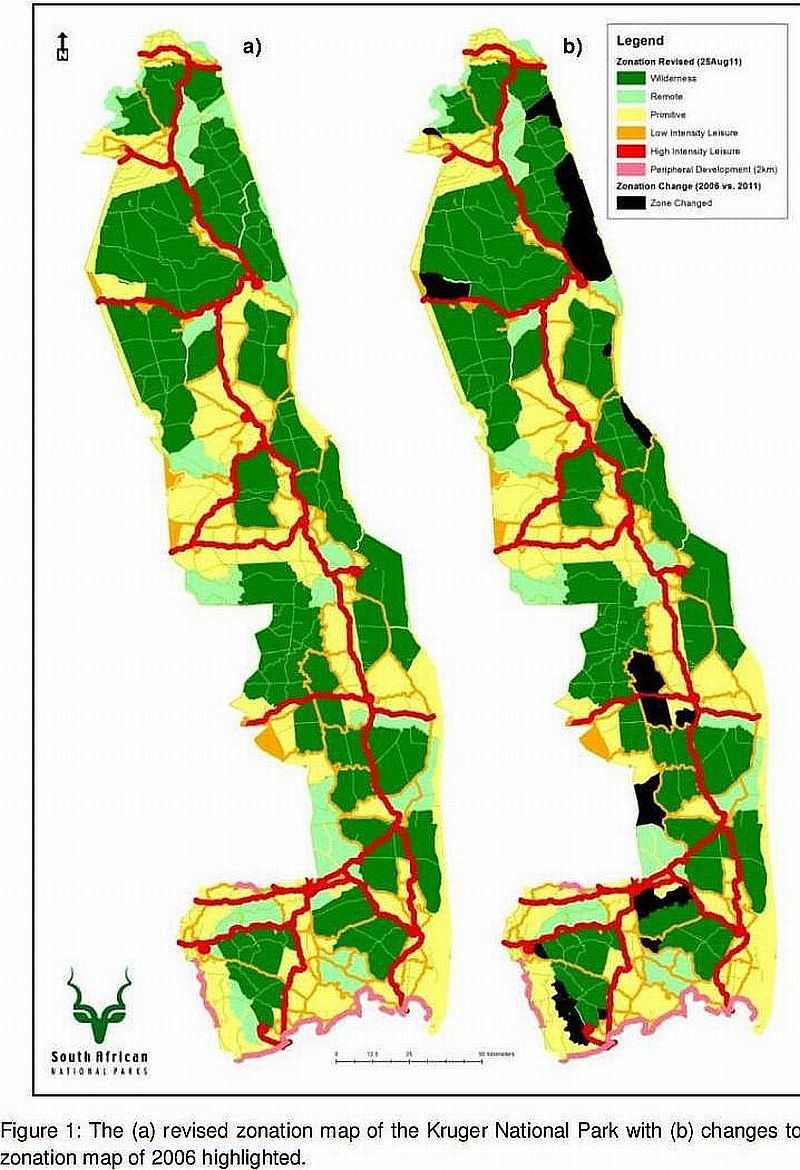
The new zonation plan for Kruger NP suggests the re-zoning of significantly larger areas in the south of Kruger NP as medium and high tourism impact zones (Figure 1). Wilderness Trails areas and zones which are used daily for day walk activities from camps will be retained. The reality is that the southern region of the park is situated in the tourism heartland associated with the Maputo development corridor linking northern KwaZulu-Natal, Mozambique and eastern Swaziland, and includes five trans-frontier conservation areas that attract an increasing number of local and foreign visitors. The Kruger NP also serves as the tourism and recreational gateway of the Greater Mbombela Local Municipality residents whose numbers have trippled the parks visitation over the last 10 years (Mpumalanga Provincial Government : Growth and Development Strategy, 2004-2014). Furthermore the Mbombela Municipality has approached SANParks with a request to open a new entrance
gate from the N4 via Kanyamazane, Luphisi and Nyongane to serve the residents of the
2
eastern rural part of the Municipality numbering approximately 600 000 in total (Mbombela Municipality, 2011). The recent developments of the Kruger Mpumalanga International Airport, the growth of Nelspruit into city status, the mushrooming of eco-towns like Marloth Park on the southern boundary, the pressure to develop lodges on the borders of the Kruger NP and growth of the Nkomazi Municipality into a regional town necessitate a change of the zoning of the south of Kruger NP from one that restricts access to an open but controlled increased visitor management system underpinned by modern techniques.
The north will largely be a wilderness destination with very little development in future. In addition, buffers were added to existing road reserves to limit developments by the type of roads and its surrounding zoning system that would mitigate the impacts of roads on the environment. The 1km reserve on both sides of the tar road measured from the central line whilst gravel roads are buffered at 500m on both sides of the road measured from the central line. All weathered roads (i.e. concession gravel roads, guided eco-trail routes, self drive eco-trail routes, access roads to trails and camps) are buffered at 250m and non all weather roads (i.e. management tracks) are buffered at 100m on both sides of the road. Buffers were also assigned to tourism camps as a gradient of development emanating from camps with variable levels of impacts associated with camp activities. As a result High Intensity Leisure areas surrounding large tourism camps were extended by a radius of 2km, Low Intensity Leisure areas surrounding smaller tourism camps are extended by a radius of
1km (Table 1).
2.2 Social justice and Socio-economic upliftment
SANParks acknowledges that millions of people live in squalid settlements dotting the boundaries of Kruger NP and are pinning their hopes for improved fortunes on land claims they've lodged in the Park, as they're entitled to under land restitution law. In the case of Kruger National Park 60% of its area has been gazetted as legitimate restitution claims that must still be settled. Land claims have brought irreversible change in a post-apartheid Kruger NP and at least 500 000 hectares of land inside the park would be managed differently from the past. It is for this reason that provision is made for the management implications of land claims in the revised zonation system.
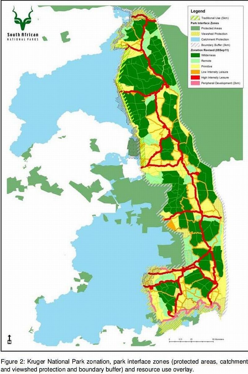
According to Statistics South Africa the Kruger NP is surrounded by three million people living within 181 villages. These people must be legitimate beneficiaries of the Kruger NP. To enable SANParks to deliver on its vision of “Connecting to Society” and in addition to the provision for land claims, the following zones were added: a Peripheral Development Zone which extends 2 km into the Park and a Multiple Use Zone which extends 3 km outside the boundary of the Kruger NP and 5 km inside the boundary of the Kruger NP. In these areas the Kruger NP management may enter into agreements with communities for joint ventures (Figure 1). The Peripheral Development Zone provides an opportunity for socio-economic development opportunities within a 2km buffer from the boundary of the park that would support job creation amongst communities. These development opportunities include park entrance gates, reception, ablution facilities, parking areas, interpretative centre and accommodation facilities such as rest camps, lodges, bush camps, picnic sites, view sites
and rustic picnic sites. The Peripheral Development Zone also affords viewshed protection in
3
support of conservation and the management of wilderness areas. In addition to the development opportunities the PDZ offers the Kruger NP management with opportunities to establish a buffer zone area between the Massingir Dam and the Nkomati River on the eastern boundary to address rhino poaching (and possible future elephant poaching) emanating from Mozambique (see Section dealing with the GLC conservancy)
In an attempt to connect Kruger NP with the local people, a Multiple Use Zone was created for the management of natural resources to benefit communities. For this reason, a 3km area directly adjacent to the Kruger NP boundary is intended to be a multiple use zone in accordance with the Department of Environmental Affairs’ policy on buffer zones for National Parks to further SANParks community socio-economic upliftment and benefit-sharing objectives (Figure 2). The revised zonation plan therefore includes traditional use management areas leaning from the current traditional use of natural resources in the Kruger NP. Responsible and sustainable use of natural resources may take place in these traditional use management areas which extend for 5kms into the National Park. These include the harvesting of mopane worms, medicinal plants, thatch grass, road verge clearing and reed clearing as well as community-driven tourism products, including traversing rights (Nkambeni and Mjejane communities as examples).
2.3 Tourism development
Tourism is one of the fastest growing sectors of South Africa's economy. Ideally placed between the Limpopo and Mpumalanga Provinces, Kruger NP revised zonation system encourages and facilitates the holistic development and promotion of the tourism industry between the provinces to ensure that all people have equal access to the social, economic and environmental opportunities and benefits created by the tourism industry for the region as a vehicle to reduce poverty and promote economic growth. In addition to tourism as new employment opportunities around Kruger NP, the Maputo development corridor linking northern KwaZulu-Natal, Mozambique and eastern Swaziland, and includes five trans- frontier conservation areas, attracts an increasing number of local and foreign visitors as well as business opportunities t o st im ulat e r eg iona l i nt eg r at ion an d boost t our ist num ber s g iving r ise t o j ob oppor t unit ies.
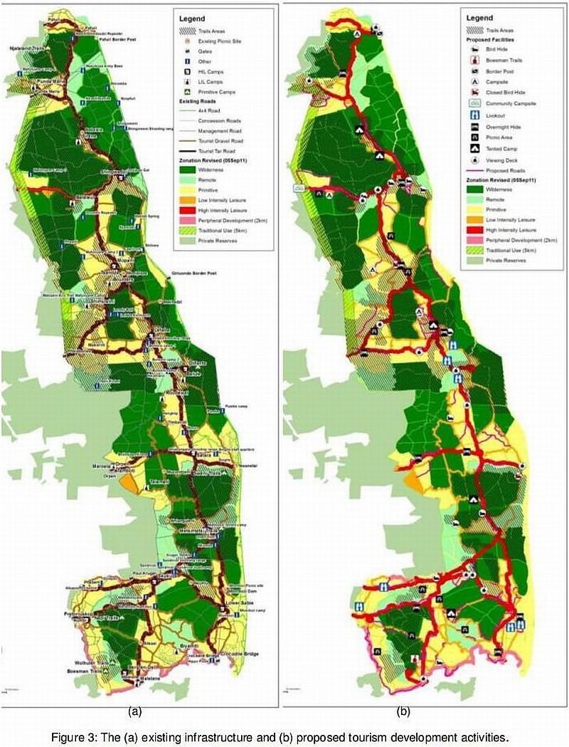
It is a fact that the views and aspirations that shaped Kruger NP’s evolution and development of facilities reflect those of the affluent sections of the apartheid society. The views of the black communities living around the park were totally ignored by previous park management who regarded them as a nuisance and a source of cheap labour for the comfort of the privileged elite (Mabunda, 2003). In response to a recent stakeholder needs assessment in-line with the tourism objectives for Kruger NP, potential areas for nature- based non-motorised and motorised tourism activities (such as wilderness camping, overnight trails, bird hides, rustic tented camps, rustic picnic spots, guided 4x4 overland eco- trails and self-drive eco-routes) were identified (Figure 3). Additional gravel loops and look- out points were placed along the main tourist roads to enhance the self-drive experience and reduce congestion.
2.4. Greater Lebombo Conservancy (GLC) Buffer-zone
4
The old Kruger Zoning Plan has become obsolete over the years as a result of cross- boundary developments that led to the signing of the Great Limpompo Transfrontier Park Treaty on 9th December 2002 by the Republics of South Africa, Mozambique and Zimbabwe giving birth to the now famous Great Limpopo Transfrontier Park (GLTP). The treaty established the core Transfrontier Park consisting of the Limpopo National Park (Mozambique), Kruger NP and Makuleke region (South Africa) and Gonarezhou National Park/Malipati Safari Area/Manjinji Pan Sancturay (Zimbabwe). Furthermore the treaty made provision for future inclusion of additional areas (Article 2 (a)(b) like Banhine and Zinavhe, the Massingir and Corumana areas as well as interlinking regions and some areas on the western boundary of the Kruger NP (South Africa) consisting of state and privately-owned land. In the preamble of the treaty the countries undertook to establish the GLTP to promote ecosystem integrity, biodiversity conservation and sustainable socio-economic development across international boundaries. Article 4 of the treaty translates this over-arching goal into 6 specific objectives which promote trans-national collaboration and cooperation among parties to facilitate effective ecosystem management in the entire GLTP.
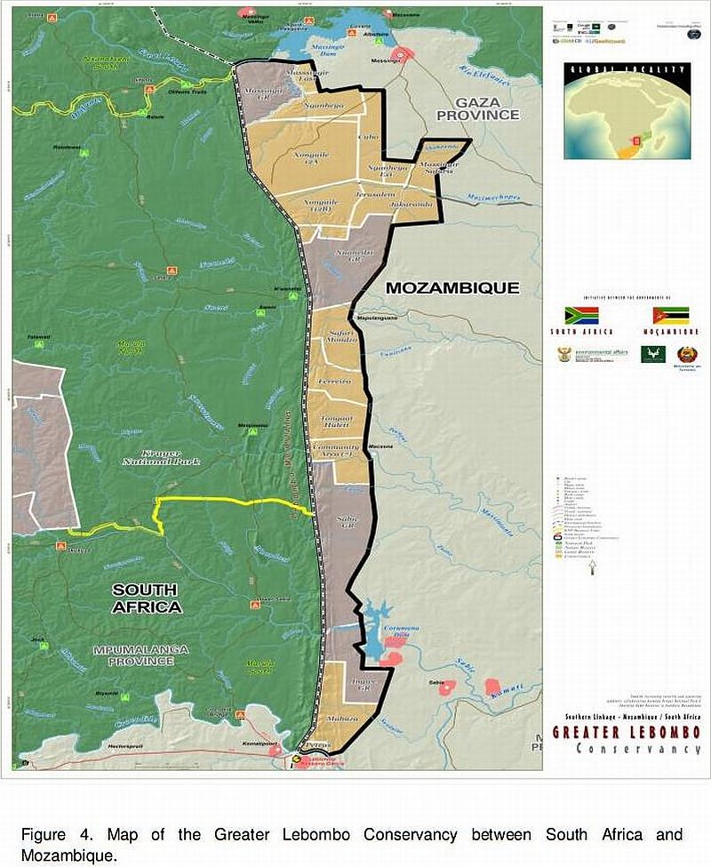
In was in the above context that the Ministers responsible for the management of the national park systems in both Mozambique and South Africa met on 06 February 2012 in Pretoria to give effect to the provisions of Article 2(a)(b) of the GLTP treaty. Article 4(b) of the GLTP treaty explicitly empowers the parties to “promote alliances in the management of biological resources by encouraging social, economic and other partnerships among the Parties, including the private sector, local communities and non-governmental organizations. The Mozambican and South African Governments have identified the need to formalize the Greater Lebombo Conservancy as part of the GLTP and a buffer zone to control the rampant rhino poaching cross-border crime and encourage the private sector concessionaires operating in the GLC to be part of this initiative. At the Pretoria February 06 meeting the Ministers responsible for the management of national parks in both countries approved the concept of including the GLC buffer zone in the PDZ extending from the south of the Kruger NP towards the east in Mozambique and to the Massingir Dam in Mozambique.
Once established the GLC buffer zone will become the first shield of defence against rhino poaching, provide ecotourism development opportunities (on the Mozambican side) for the private sector investors and create a logical deterrent to poaching activities through the tourism activities. In the spirit of the GLTP treaty the PDZ, as a development corridor, had to include the GLC bufferzone in a continuous belt bordering the park from the south, east and south of the Massingir Dam (Figure 4).
3. CONCLUSION
The new Kruger Zoning Plan is a revolutionary and living document which embraces both external and regional dynamics in addition to internal activities. It is also unique in the sense that it combines the imperatives of biodiversity conservation, law enforcement, tourism development, trans-frontier park regional initiatives and the socio-economic upliftment of communities in the whole region. It is a true reflection of the variables that should be given recognition when drawing both a park management plan and zoning plan to manage national
parks in 21st Century.
5
4. REFERENCES
Joubert, S.C.J. 1986. Masterplan for the management of the Kruger National Park, Vols I-VI.
Unpublished document, Skukuza Archives, Kruger National Park.
Mabunda, M.D. 2003. An Integrated Tourism Management Framework for the Kruger
National Park, South Africa. PhD thesis, University of Pretoria.
Mbombela Municipality, 2011, Presentation by University of Central Florida, September
2011. Unpublished document.
Mpumalanga Provincial Government: Provincial Growth and Development Strategy (2004-
2014), 2008 Review. Unpublished document
Venter, F. Freitag-Ronaldson, S., Kalwa, R., Badenhorst, J., Erasmus, J. and F. Nel. 1997.
Recreational Opportunity Zoning within the Kruger National Park. Kruger National Park internal report.
Venter, F.J. 1990. A classification of land for management planning in the Kruger national
Park. PhD thesis, University of South Africa, Pretoria.
Treaty between the Government of the Republic Mozambique and the Government of the
Republic of South Africa and the Government of the Republic of Zimbabwe on the establishment of the Great Limpopo Transfrontier Park, 2002, Unpublished Report