The ABC of Kruger

Have some fun answering Quizzes of a wild nature and learn at the same time
User avatar
Richprins
Committee Member
Posts: 75579
Joined: Sat May 19, 2012 3:52 pm
Location: NELSPRUIT
Contact:

Re: The ABC of Kruger

Post by Richprins »

Kruger Gate


k.jpg
Maybe it should come under P? :-? O-/

https://africawild-forum.com/viewtopic.php?f=36&t=7050
Last edited by Richprins on Sun Sep 08, 2019 8:21 am, edited 1 time in total.


Please check Needs Attention pre-booking: https://africawild-forum.com/viewtopic.php?f=322&t=596
User avatar
Alf
Posts: 10708
Joined: Wed Nov 26, 2014 12:40 pm
Country: south africa
Location: centurion
Contact:

Re: The ABC of Kruger

Post by Alf »

Klopperfontein Dam

This dam is located on the S61 close to Punda Maria rest camp.

Image


Next trip to the bush??

Let me think......................
User avatar
Lisbeth
Site Admin
Posts: 66732
Joined: Sat May 19, 2012 12:31 pm
Country: Switzerland
Location: Lugano
Contact:

Re: The ABC of Kruger

Post by Lisbeth »

Kwaggaspan Pan (Kwagga is Afrikaans for zebra)

In 1976, this borehole was sunk and named by Mr Jim Meiring.

On the H3. Going north just before the S112 turn-off.

This area was used as a campsite by Carolus Trichardt, who was commisioned to build a road between Pretoriuskop and Delagoa Bay, which served as a trade route.

Image


"Education is the most powerful weapon which you can use to change the world." Nelson Mandela
The desire for equality must never exceed the demands of knowledge
User avatar
Richprins
Committee Member
Posts: 75579
Joined: Sat May 19, 2012 3:52 pm
Location: NELSPRUIT
Contact:

Re: The ABC of Kruger

Post by Richprins »

Kremetart Windmill

Long-defunct windmill just north of Klopperfontein. Saw my first and only Knysna Parrot there!

Kremetart is Afrikaans for baobab.
k.jpg


Please check Needs Attention pre-booking: https://africawild-forum.com/viewtopic.php?f=322&t=596
User avatar
Richprins
Committee Member
Posts: 75579
Joined: Sat May 19, 2012 3:52 pm
Location: NELSPRUIT
Contact:

Re: The ABC of Kruger

Post by Richprins »

Komapiti

Long-defunct waterhole on the H2-2 Voortrekker road.

k.jpg
Komapiti may mean "carpet".


Please check Needs Attention pre-booking: https://africawild-forum.com/viewtopic.php?f=322&t=596
User avatar
Richprins
Committee Member
Posts: 75579
Joined: Sat May 19, 2012 3:52 pm
Location: NELSPRUIT
Contact:

Re: The ABC of Kruger

Post by Richprins »

Kruger Tablets


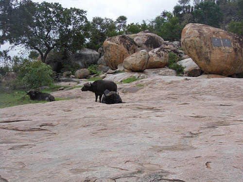
Memorial plaque along the Tshokwane - Skukuza tar road commemorating Paul Kruger, one of the founders of the Park.

Image
Pic by Dzombo


Image
Old Custos pic


There is some debate as to whether one can get out there or not! lol

https://www.africawild-forum.com/viewto ... 243&t=5320


In 1933, big bronze memorial tablets were fixed to the flat granite surfaces of this koppie to honour Paul Kruger and Minister Piet Grobler for their work in the Park.

The hill is called Krugertabletkoppie.
Last edited by Richprins on Tue Oct 29, 2019 7:57 am, edited 1 time in total.


Please check Needs Attention pre-booking: https://africawild-forum.com/viewtopic.php?f=322&t=596
User avatar
Lisbeth
Site Admin
Posts: 66732
Joined: Sat May 19, 2012 12:31 pm
Country: Switzerland
Location: Lugano
Contact:

Re: The ABC of Kruger

Post by Lisbeth »

Klein-Nshawu Waterhole

Close to the Letaba/Mopani road (H1-6) 4 km before the turnoff to the H14, going north.

Image


"Education is the most powerful weapon which you can use to change the world." Nelson Mandela
The desire for equality must never exceed the demands of knowledge
User avatar
Richprins
Committee Member
Posts: 75579
Joined: Sat May 19, 2012 3:52 pm
Location: NELSPRUIT
Contact:

Re: The ABC of Kruger

Post by Richprins »

Klein Letaba

The "small" Letaba is actually one of the Park's biggest seasonal rivers and forms the Western boundary for 30km or so in a very remote part of SA north of Phalaborwa.

k.jpg
k.jpg (154.56 KiB) Viewed 753 times

It enters Kruger at the top red circle and joins the Big Letaba at Mahlangeni Ranger's Post at the bottom.


Please check Needs Attention pre-booking: https://africawild-forum.com/viewtopic.php?f=322&t=596
User avatar
Richprins
Committee Member
Posts: 75579
Joined: Sat May 19, 2012 3:52 pm
Location: NELSPRUIT
Contact:

Re: The ABC of Kruger

Post by Richprins »

Kaleka


Hill and stream a few km south of Mopani Camp.


The little one on the far left:
k.jpg

Kaleka, Tsale and Ngodzi are three prominent hills that clearly dominate the landscape there!

Origin: Tsonga

Meaning: From the word khaleka, meaning 'to have a desire for something'.

This is the smallest of the three hills to the west of the Tsende and is situated slightly further south. The Kaleka spruit, originating between the Kaleka and Tsale Hills and flowing eastwards into the Tsende, is named after this hill.


Krugerpark News
Last edited by Richprins on Tue Nov 05, 2019 9:01 am, edited 2 times in total.


Please check Needs Attention pre-booking: https://africawild-forum.com/viewtopic.php?f=322&t=596
User avatar
Lisbeth
Site Admin
Posts: 66732
Joined: Sat May 19, 2012 12:31 pm
Country: Switzerland
Location: Lugano
Contact:

Re: The ABC of Kruger

Post by Lisbeth »

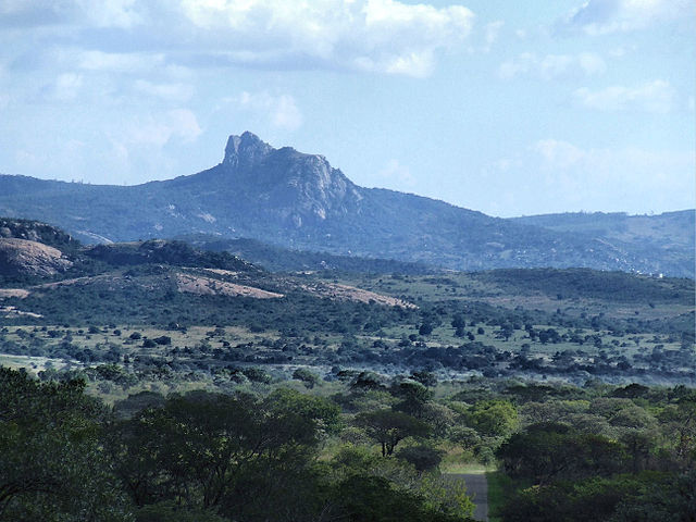
Khandzalive Hill

The highest point of the Kruger National Park (840 m), in the southwestern corner near Berg-en-dal Camp.
Image

Khandzalive was always known as Khandizwe. It is unique in the fact that Kruger Park introduced grey rhebuck to its summit via helicopter in the 1980s, as they believed the antelope had lived or could live there. This was a failed experiment, it seems.

This koppie, boasting a beacon which marks the highest
point (839m) within the KNP, comes from a Siswati word
which means “the founding of a settlement”. - Vd Wateren

"Education is the most powerful weapon which you can use to change the world." Nelson Mandela
The desire for equality must never exceed the demands of knowledge
Post Reply

Return to “Africa Wild Quizzies & Games”